
© M. Schauer
SPACEWHALE – whale surveys from space
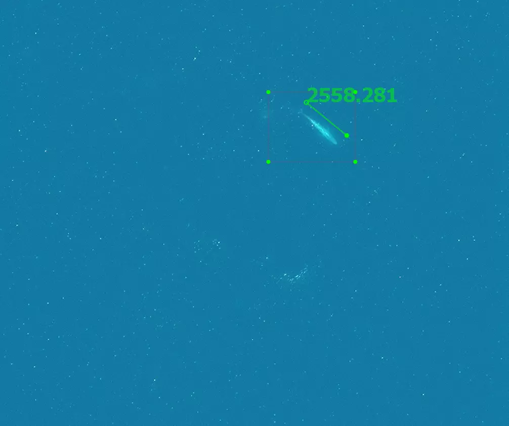
SPACEWHALE is a service providing AI-based detection of large whales in very high-resolution satellite imagery.

Please refer to the website of the service for further information about SPACEWHALE. www.spacewhales.de
A combination of deep learning and expert knowledge
SPACEWHALE uses a semi-automated process to evaluate satellite imagery, combining state-of-the-art artificial intelligence and manual verification by a team of marine mammal experts.
- In a first step, the SPACEWHALE algorithm scans the satellite imagery for the presence of whales.
- In the second step, our experts review the detected objects to verify the classification and identify the species.
Using this approach, areas with no whales are excluded by the algorithm and large, difficult to access survey areas can be processed in a relatively short time.
The method allows monitoring remote and unexplored regions in the high seas, where traditional ship-based or aerial surveys are difficult to carry out or even impossible.
Several studies document the accuracy of this method (Borowicz et al. (2019), Höschle et al. (2022)).
SPACEWHALE processes the very high-resolution imagery immediately and the results are quickly made available for the client. The client receives sections of the imagery including the detected marine mammals, tables indicating the abundance as well as maps showing the distribution of the animals.
Experts from industry, government and nature conservation can use these data in baseline studies, environmental impact assessments or monitoring.
Our services in detail
Abundance estimates
We provide abundance estimates and determine the minimum species density for large whales or wildlife species on a per-survey basis which can be used to generate population trends over time.
Distribution maps
Using advanced modelling techniques, we create distribution maps of target species in ESRI-compatible raster formats.
Bespoke analyses
In cooperation with our clients we offer bespoke analyses to support conservation and advanced ecological studies.
Reference projects

Papers and reports

Satellite surveys prove a reliable monitoring method for high latitude southern right whale habitat
International Whaling Commission
https://www.spacewhales.de/wp-content/uploads/2022/06/SC_68D_SH_12.pdf

The Potential of Satellite Imagery for Surveying Whales
Sensors 2021, 21, 963

Aerial-trained deep learning networks for surveying cetaceans from satellite imagery
PLoS ONE 14(10): e0212532
Further information
- In 2023, SPACEWHALE was attending the 28th UN Climate Change Conference and took part in various events.
- The recording of a panel discussion on "Using state-of-the-art technologies like satellite imagery and AI to enhance marine conservation and reach the 30x30 target" can be found here: https://www.youtube.com/watch?v=UeI-b3_084o
- The recording of a presentation by our colleague Julika Voß can be found here (the presentation by Julika Voß starts at 25:30): https://www.youtube.com/watch?v=YN_TgeB4VPg
- In May 2023 our SPACEWHALE service became finalist of the Expo Live Innovation Programme.
- In January 2023, the World Economic Forum (WEF) selected the SPACEWHALE team as one of the winners of the Ocean Data Challenge. This brings SPACEWHALE into the WEF's UpLink Innovation Network, including a mentorship program and partnership opportunities: https://uplink.weforum.org/uplink/s/uplink-contribution/a012o00001pUR2pAAG/SPACEWHALE%20-%20Mapping%20whales%20from%20space%20using%20AI%E2%9C%AA
In June 2022, the SPACEWHALE team was named the champions of the 2022 Deloitte Gravity challenge with Whale and Dolphin Conservation: https://gravitychallenge.space/gravity-04-challenge-solutions-awards. This prize gives SPACEWHALE the opportunity to create a baseline for the designation of further marine protected area and to globally promote the protection of marine mammals: https://www2.deloitte.com/uk/en/pages/innovation/solutions/wdc.html.
- In February 2022, the SPACEWHALE team was given the opportunity to present our applied technology at MAXAR Smart talks. Join our BioConsult expert for this in-depth talk on spotting whales from space: https://engagesmarttalks.maxar.com/smart-talk/spotting-whales-from-space
BioConsult SH has developed SPACEWHALE in collaboration with HiDef Aerial Surveying Ltd. The project was co-funded by the European Space Agency (ESA).
Please visit the website of the European Space Agency (ESA) for further information:
Contact

Caroline Höschle
Deputy team lead
Remote sensing
SPACEWHALE

 bioconsult-sh.de